
ABOUT US
A Very Brief History of Robeson Township
Robeson Township, Berks County, Pennsylvania was established in 1729, named for either Andrew Robeson, Jr. or his son Israel Robeson.
Andrew Robeson, Jr. bought 600 acres of land in 1716 in what would become Robeson Township. He never lived on this land, but his son Israel did.
This 600 acre tract of land is bounded by present-day Schuylkill River to the North, Cedar Hill Road to the West, the area around Cedar Hill Flowers Corporation to the South and the Robeson Township - Birdsboro Borough municipal boundary line to the East.
In the 1700s Robeson Township was home to early European settlers and native Indians who lived peacefully among each other. The early settlers were starting their forges and mills along the many creeks of the township and became very prosperous.
In the 1800s came the Schuylkill Canal, Philadelphia & Reading Railroad and the Pennsylvania Railroad through the northern portion of the township. With them came major changes in the township. Industry became much larger due to the fact that they now had upgraded transportation to ship their products to Reading, Philadelphia, New York or elsewhere. They no longer had to rely on very crude road paths. With more industry came more residents and many one-room schools, churches and hotels were built for the increased population. In 1845 there was a plan to divide the township in half. The southern half would have been renamed Hay Creek Township, but on March 7, 1846, the proposal was rejected.
The early 1900s brought the Birdsboro Trolley through the northern portion of the township that ran from Birdsboro to Reading. The demise of the early forges and mills were continuing. Thanks to the Gickersville resident, Sylvester S. Squibb, and others, there were many photographs taken of various aspects of township life at the turn of the century. By the mid-1900s became the demise of the Schuylkill Canal and the Birdsboro Trolley line. The late 1900s brought in many housing developments just about everywhere in the township where there was a farm or open land, but luckily, Robeson Township still has many beautiful farms and open space for us to enjoy while driving the back roads.
This short history was submitted by the Robeson Township Historical Society.
ROBESON TOWNSHIP DEMOGRAPHICS
As of the census of 2020, there were 7,538 people, and 2,768 households, and 1,965 families residing in the township. The population density was 222.4 people per square mile (78.2/km²).
The racial makeup of the township was 97.09% White, 0.3% African American, 0.2% Asian, and 1.4% from two or more races. Hispanic or Latino of any race were 2.3% of the population.
Of the 2,768 households, 30.6% had children under the age of 18 living with them. The average household size was 2.72 persons. High school graduates or higher were 90.3%; Bachelors degree or higher were 32.6%. 64% of the population are married. Households with a computer were 95.8%; and broadband internet services were 89.8%
Historical population Census Pop. %± 1980 4,729; 1990 5,954 25.9%; 2000 6,869 15.4%; 2010 7,216 5.1%. Source: US Census Bureau
In the township the population was spread out with 24.6% under the age of 18, and 17.5% who were 65 years of age or older. The median age is 39.4, and 50% male and female. 58% of the population are between the ages of 18 to 64 years. 8.9% of the population have veteran status. The civilian labor force age 16+ is 69.4%.
The median income for a household in the township was $82,048. The per capita income for the township was $37,484. About 5.4% of the population were below the poverty line.
Owner occupied housing rate from 2017 - 2021 was 9l.1%, and 95% of all properties are occupied. The gross monthly rent for that period was $792. The median value of owner-occupied housing units is $242,600.
ROBESON TOWNSHIP MAP
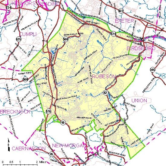
Click on the image view/download a pdf of this map.